 GPS
GPS
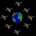
What is GPS and what can it do for you? Global Positioning System (GPS) is a method of showing your exact position on Earth anytime and anywhere. Anyone with a GPS receiver can receive signals from the GPS Satellites, which orbit the earth and are continually monitored from ground stations to determine their position.
GPS System:
The Space Group
All GPS systems are comprised of three groups: The Space Group, the Control Group, and the User Group. 24 satellites make up the Space Group that orbit 11,000 miles above the Earth. The first satellite was launched into space in 1978, the 24th and final GPS satellite was launched in 1994. Satellites take 12 hours to make one trip around the earth known as an orbit. Their position in orbit is in such a way that anywhere on Earth you can receive a signal from six satellites nearly 100% of the time. These satellites transmit a coded signal on a high-frequency radio wave. This signal transmitted is the Satellite position and the time from a very accurate clock. The clock keeps precise time, to within three nanoseconds, or one billionth of a second.
Control Group
Five ground stations make up this group. A master ground station is located at Falcon Air Force Base in Colorado Springs, Colorado. Four unmanned monitoring stations are located around the world (Ascension Island in the Atlantic Ocean; Diego Garcia in the Indian Ocean; Hawaii and Kwajalein in the Pacific Ocean). The ground stations broadcast signals to the satellites through large antennas. This tracks and monitors the satellites.
User Group
Receivers make up The User Group. GPS Receivers come in a variety of shapes and sizes. These receivers obtain, decode, and process the signal from the satellite. GPS unit receives the signal from a satellite. Information from at least three satellites allows the receiver to calculate its position. The more satellites the receiver can lock onto the more accurate your position will be. Position accuracy can be as close as eight feet to several hundred.
The United States Government operates the Global Positioning System and is solely responsible for its accuracy and maintenance. The accuracy and performance of all receivers are subject to change and can be adjusted by the controlling agency. GPS receivers require a line-of-sight reception. Without an unobstructed view of the sky receiver’s accuracy will not be optimum. Trees and mountains that can obstruct satellite signals also affect GPS accuracy.
Coordinates
There are many different grids and datum to choose from when labeling GPS waypoints. The most standard grid and easiest to understand, in the author’s opinion, is degrees of Latitude and Longitude (Lat/Lon). Another common unit today is Universal Transverse Mercator (UTM). If other units are desired, use a program like GPSbabel to convert them to the desired units.
Degrees
Lat/Lon waypoints are measured in degrees, minutes, and seconds and labeled north (N) or south (S) from the equator. Longitude is measured from the prime meridian east (E) and west (W). Latitude has a range from 0° to 90° and is labeled N or S from the equator. Longitude has a range from 0° to 180° and is labeled E or W for the direction from the prime meridian. The standard prime meridian is located in Greenwich, England a suburb of London (0° longitude).
At E180° or W180° longitude, the arcs are the same on the opposite side of the world (international dateline). As stated earlier 0° latitude is on the equator, N90° Latitude is at the North Pole and S90° Latitude is at the South Pole. There are 60 minutes to a degree and there are 60 seconds to a minute. For estimating distance 1° equals approximately 1 mile near the equator.
UTM
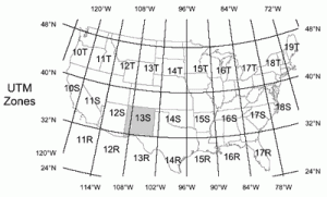
Figure 1
UTM is a metric-based grid that breaks the terrain into standardized blocks. These grids divide the earth into 6° wide by 8° tall blocks and into 1-kilometer (km) squares. To understand UTM you need to first visualize the world broken down into twenty rows and sixty columns. See Figure 3 for a complete world grid map.
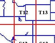
Figure 2
The areas that cover the United States are grid rows R, S, T, and U while columns are 10 through 19 (see Figure 1). A UTM waypoint (12 T 401521 3995532) shows zone (12T), east/west coordinates (401521), and north/south coordinates (3995532). Zone 12 T represents column 12 and row T. (see Figure 2)
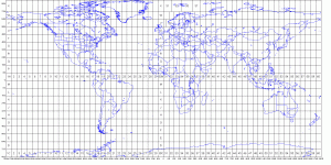
Figure 3
Finding your Position
The first thing you have to do is find the map that covers the area of your coordinates. East/West coordinates 401521 are on the bottom and top edge of the map. Start at the left corner and move right until you come to 401. Since the next number is a 5 it will be halfway across the block between 401 and 402 which would be 5/10 between the two. If you have a transparent grid, discussed later, you would be able to pinpoint the coordinates even closer. Make a tick mark.
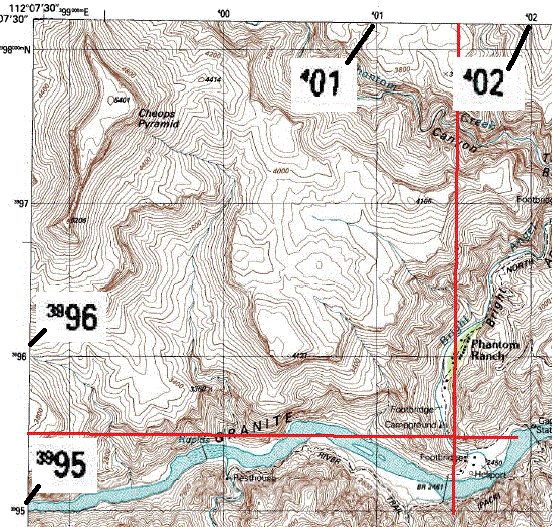
Figure 4
North/South coordinates 3995532 are on the left and right sides of the map. Starting at the bottom move up the side until you come to 3995. Again moving up the scale to halfway between 3995 and 3996 would represent the next 5 or 5/10th in the coordinates. Make another tick mark. Using a straight edge draw a line east/west and north/south, where these lines intersect will mark the location of the coordinates. See Figure 4. If you want to be more accurate you can use the next two digits in the coordinates. To do this it is essential to use a transparent grid. You would lay the grid on the map and count the lines. Make sure you are using the appropriate size grid that matches your map.
To be completely accurate you must use the same datum for both your coordinates and your map. Older maps use the 1927 North American Datum (NAD 27). Updated maps may have a comment
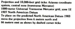
Figure 5
like the one in Figure 5. This moves the datum from where it was in 1927 to that of 1983. The directions are to move your lines 6 meters north and 66 meters east (see Figure 6) to see your exact location on the map. In the lower left-hand corner of the map, you can see where the datum moved to make
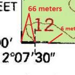
Figure 6
your adjustment.
Most modern GPS use WGS 84 which is very close to NAD 83. If you are wondering what is datum click on it for a short explanation. You can also Click here for information on using a compass and map.